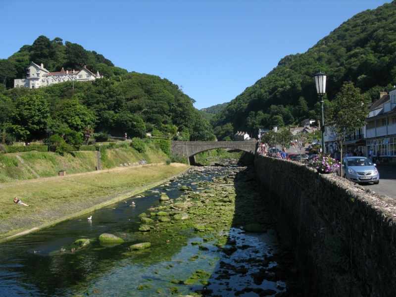
River Lyn, Lynmouth, Exmoor National Park
[Main photo: the River Lyn at Lynmouth]
The River Lyn in Exmoor National Park
Lynmouth and Lynton are two of the most popular villages in Exmoor National Park and the West Country. They’re named after the River Lyn that flows into Lynmouth Bay.
The River Lyn is fed by numerous smaller waterways that we describe below.
Location of the River Lyn
The River Lyn and its many tributaries flow from Exmoor’s high moor around The Chains, Exe Plain, Brendon Common and Madacombe down to Lynmouth and the Bristol Channel towards the western end of the Exmoor coast.
Directions to, and parking at, the River Lyn
The River Lyn and its tributaries cover a large area of Exmoor National Park. We recommend a few parking areas below.
Lynmouth. There’s a large car park in the centre of the village (Lyndale Cross Car Park/Upper Lyndale Car Park) by the River Lyn.
Watersmeet. Try the car park above Watersmeet on Watersmeet Road/A39 (Watersmeet Road Car Park).
Brendon Common. The B3223 cuts across Exmoor’s high moor. We tend to walk from the car parks by Dry Bridge.
Simonsbath. There’s parking up the road from the pub. This is marked on Ordnance Survey mapping. We normally walk to The Chains from here although there’s parking along the B3223 as well just south of Exe Head Bridge.
The River Lyn
Most of the major Exmoor and Dartmoor rivers have headwaters that share their name. The River Exe rises at Exe Head. The River Dart rises at the West Dart Head and East Dart Head. The River Lyn is different. It’s fed by numerous smaller waterways. As such, we describe the River Lyn as it moves upriver from the coast and Bristol Channel.
Lynmouth Bay is located in the central coastal section of Exmoor National Park. The bay takes its name from the super popular Lynmouth village and the mouth of the River Lyn at Lyn Mouth. The famous Exmoor beauty spot The Valley of Rock is to the east. The Foreland and Foreland Point are to the west. Both are accessible on the South West Coast Path and provide amazing views.
Lyn Mouth is flanked by Lynmouth Eastern Beach and Lynmouth Western Beach by Lynmouth Harbour. The river and seafront are lined with shops and some great places to eat and drink including the Esplanade Fish Bar Restaurant & Takeaway and The Rising Sun pub. The lower part of Lynton and Lynmouth Cliff Railway is situated by Lyn Mouth. Boat trips run from the harbour.
The River Lyn is fed by the West Lyn River and East Lyn River in the centre of the village. These are described below.
The West Lyn River
The West Lyn River runs through Glen Lyn Gorge. This is one of Lynmouth’s main visitor attractions. It’s a beautiful steep-sided valley cut by the West Lyn River. Information boards tell the story of the 1952 that devastated the area.
‘The Glen Lyn Gorge is designated a Site of Special Scientific Interest for its fluvial geomorphological (flood deposited) boulder fields. Geologically young the gorge remains steep allowing fast flowing flood waters to carry heavy boulders.
The gorge was created when the West Lyn River changed course from its original route through the Valley of Rocks, finding a shorter path to the sea at Lynmouth.’ (Source: information board on site.)
The West Lyn River and B3234 then meander to Barbrook where the waterway splits again. The West Lyn River extends to various headwaters on remote high moor called The Chains. Barbrook arcs west and then south to headwaters around Longstone Barrow/Long Stone, Cannon Hill and Parracombe Common. Again, this is remote high moor.
The East Lyn River
The East Lyn River runs through a stunning steep-sided valley (Lyn Cleave and then Myrtleberry on both Ordnance Survey and Harvey Maps) to the National Trust’s Watersmeet.
The waterway splits. Farley Water and Hoaroak Water run south to headwaters on remote high moor at Exe Plain near Exe Head.
The East Lyn River continues east through a heavily wooded valley to Doone Country around Malmsmead and Oare. From there, the East Lyn River splits into Oare Water and Badgworthy Water.
Oare Water heads south east to Chalk Water and Weir Water which have their headwaters on remote high moor around Madacombe.
Badgworthy Water cuts Doone Valley and is fed by various other waterways such as Hoccombe Water on Brendon Common.
In short, many of the waterways rising on Exmoor between Dunkery Beacon to the east and Blackmoor Gate to the west flow into the East Lyn River and West Lyn River before these rivers meet in Lynmouth and flow into the Bristol Channel at Lyn Mouth.
Other major rivers in Exmoor National Park
River Exe. River after which Exmoor is named. Rises on the high moor at Exe Plain near The Chains Valley and The Chains close to the B3223 (see Ordnance Survey mapping for detail). It cuts through the beautiful Exe Cleave on its way to Exford and Winsford before running on the west side of the A396 to the border of Exmoor National Park. The River Exe is joined by the River Barle just north of Exebridge.
River Barle. Another river rising on the high moor at Pinkery Pool on The Chains. It flows down to the moorland village Simonsbath past Cow Castle to the beauty spot Landacre Bridge. The river then continues to the village Withypool before flowing under the famous Tarr Steps on its way to Dulverton, the southern border of Exmoor National Park and then the River Exe.
River Heddon. River on the western side of the national park that cuts the amazing Heddon’s Mouth Cleave that runs to the coast at Heddon’s Mouth Beach. The section of river and cleave/valley between the Hunter’s Inn and Heddon’s Mouth Beach are deservedly super popular. The South West Coast Path and Tarka Trail cross the river in the cleave/valley. The River Heddon rises near Chapman Barrows on the high moor. A smaller tributary flows from the Blackmoor Gate area and arcs around to meet the River Heddon near Hunter’s Inn.
River Avill. River on the eastern side of Exmoor National Park that flows past Dunster to meet the Bristol Channel at Blue Anchor Bay. The River Avill rises on Dunkery Hill close to the moorland road that provides easy walking access to Dunkery Beacon. Several smaller tributaries join the River Avill in the Timberscombe area. Another comes down from Croydon Hill near Dunster.
Other recommended smaller rivers in Exmoor National Park
Horner Water. This is the main river in Dunkery and Horner Wood National Nature Reserve. The river that flows through the magnificent Horner Wood on its way to Porlock Vale, Bossington and then the Bristol Channel at Porlock Bay. Horner Water is also fed by numerous smaller waterways such as East Water (coming down from Dunkery Hill) and Nutscale Water (coming down from the Nutscale Reservoir area). Explore from the large car parking area at Webber’s Post. Spring and autumn are glorious.
Hawkcombe Water. This is the stream that runs through Hawkcombe Woods National Nature Reserve. The stream rises at Hawkcombe Head on Porlock Common, runs through the amazing woods on its way to Porlock and the Bristol Channel at Porlock Bay. Walk up from Porlock or use one of the car parking areas on the A39 and drop down into Hawkcombe Woods National Nature Reserve to experience Hawkcombe Water. Spring and autumn are glorious as well.
Places to eat and drink near the River Lyn
Lynmouth. The area around Lynmouth Harbour is packed with places to eat and drink and shops selling ice cream and local produce. It’s best to wander around and see what takes your fancy.
Watersmeet. The tea room and garden at Watersmeet (National Trust). Enjoy a cream tea in a wonderful setting in this steep-sided and heavily wooded valley.
Simonsbath. The Exmoor Forest Inn is superb if you’re exploring headwaters on the high moor.
Villages and towns near the River Lyn
Lynmouth. Famous West Country village and part of ‘England’s Little Switzerland’.
Lynton. Again, famous West Country village and part of ‘England’s Little Switzerland’. Sits above Lynmouth and close to The Valley of Rocks.
Simonsbath. High moorland village through which the Two Moors Way runs. Walking country with a great pub. Provides access to Exe Head, Exe Plain and The Chains if you’re wanting to experience the fort of remote moorland you find on the much larger Dartmoor.
Malmsmead and Oare. Hamlet and village in Exmoor’s Doone Country. Great walking. We’d recommend following the path that runs by Badgworthy Water to the site of the medieval village in Doone Country in the heart of the moor.
Martinhoe and Woody Bay. A sublime stretch of the Exmoor coastline. Woody Bay Station is inland near headwaters and streams that flow into the West Lyn River.
Photo Gallery