Minehead South West Coast Path Walk, Minehead, Exmoor National Park

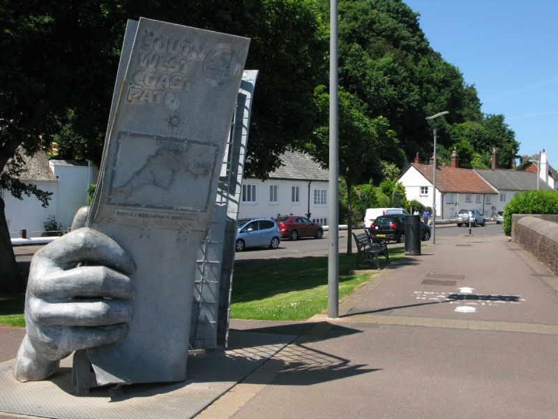
[Main photo: the South West Coast Path Start/End Sculpture near Minehead Harbour and below North Hill in Minehead]
Minehead South West Coast Path
Minehead is at the start/end of one of the UK’s most well known long distance walking paths.
Location of Minehead South West Coast Path
The South West Coast Path runs from Minehead along the Exmoor coastline to Combe Martin and then the North Devon National Landscape.
We’ve positioned the start/end of the South West Coast Path at Minehead on Google maps. Zoom in on the ‘Satellite’ setting to see its location.
Directions to, and parking at, Minehead South West Coast Path
Walk the Esplanade and then Quay Street in the direction of Minehead Harbour. You’ll see The Quay Inn on the left and the large South West Coast Path Start/End Sculpture on the right.
There’s street parking along the Esplanade and Quay Street. There are various car parks in town. Try Station Car Park, North Road Car Park, Clanville Car Park, Summerland Car Park and Alexandra Car Park. There are lots of car parks by Butlin’s Minehead if you’re staying there.
You can also park at Quay West Car Park by Minehead Harbour and wander back down Quay Street to get to the South West Coast Path Start/End Sculpture.
The South West Coast Path at Minehead
The South West Coast Path starts/ends at the South West Coast Path Start/End Sculpture near Minehead Harbour and below North Hill in Minehead. The sculpture is across the road from The Quay Inn.
From the South West Coast Path Start/End Sculpture, walk towards Minehead Harbour. The path continues above the sand and stone beach to Culver Cliff and Culver Cliff Sand where it then zig-zags steeply to the top of North Hill. Detour to see the remains of Burgundy Chapel or North Hill’s highest point at Bratton Ball.
North Hill is a part of a huge, whaleback hill that runs from Minehead across to Porlock Vale. North Hill is at the eastern end of this whaleback. Bossington Hill is at the western end. At 308 metres above sea level, Selworthy Beacon is the highest point.
North Hill provides amazing views of Minehead, Minehead Beach, the West Somerset coast and the Bristol Channel. Exmoor’s highest point, Dunkery Beacon on Dunkery Hill, is to the south west. Porlock Vale and the extraordinary Exmoor coastline are to the west.
The South West Coast Path runs across the whaleback hill and splits/joins on North Hill. One section of the South West Coast Path runs along the steep coast. The other section runs along the top of the whaleback hill and passes by Selworthy Beacon. Note that the South West Coast Path joins/splits on Bossington Hill as well. See Ordnance Survey mapping for detail. If you’re walking the South West Coast Path here, you have a choice between coast and high ground.
Walking the South West Coast Path west to Porlock Weir
From this high ground, the path drops down to Porlock Bay and crosses Sparkhayes Marsh (National Trust) on its way to the very pretty Porlock Weir.
Note that you cannot walk along the shingle ridge to Porlock Weir owing to a sea breach. The South West Coast Path is well signposted across the marsh.
You come to the pebbles of Porlock Beach by the Submarine Forest. Wander across to the very pretty Porlcok Weir.
Walking the South West Coast Path west from Porlock Weir to Lynmouth
From Porlock Weir, the South West Coast Path runs along heavily wooded coastline.
At Culbone, it splits again and a higher route runs above the heavily wooded coastline before rejoining the coastal route at Glenthorne Beach.
The South West Coast Path then continues through heavily wooded coastline past the wonderfully named Desolation Point on its way to Foreland Point. The path climbs and then crosses The Foreland. Note that there’s a path that runs around The Foreland but it’s super steep so avoid and stick to the South West Coast Path.
You then skirt The Foreland in the direction of Countisbury. The views across to Lynmouth and Lynton and down the Exmoor coastline are remarkable here.
The path then runs alongside/along the A39 on your descent into Lynmouth.
Walking the South West Coast Path west from Lynmouth to Combe Martin
This section takes you along the highest sea cliffs in England.* There are many very steep valleys here so the walking is tiring.
*[Depending on definitions, ‘Exmoor has the highest sea cliffs on the British mainland. Exmoor has the highest coastline on the British mainland. It reaches a height of 314 metres (1350 feet) at Culbone Hill. However, here the crest of the coastal ridge of hills is more than a mile from the sea. If a cliff is defined as having a slope greater than 60 degrees, the highest cliff on mainland Britain is on Great Hangman near Combe Martin. The coastal hill is 318 metres (1043 feet) high with a cliff face of 250 metres (800 feet). (Source: Exmoor Bunkbarn website.)]
Walking the South West Coast Path from Combe Martin to Woolacombe
The South West Coast Path leaves Exmoor National Park at Combe Martin and enters the North Devon National Landscape. It’s a super walk to Woolacombe.
South West Coast Path Bossington Hill loop
For a short-ish circular walk from Minehead incorporating the South West Coast Path, follow the directions above (Minehead section) to North Hill. Walk the South West Coast Path along the coastline and then loop back on the upper South West Coast Path route. Take one of the higher paths as marked on Ordnance Survey mapping to return to Minehead.
South West Coast Path, Dunkery Beacon and Dunster loop
If you’re very fit, this is a super walk. It’s marathon length with roughly 5000 feet ascent.
Follow the South West Coast Path to the Porlock area.
Leave the South West Coast Path and yomp up to the amazing Horner Wood National Nature Reserve.
Continue your ascent to Dunkery Beacon.
From Dunkery Beacon descend on the Macmillan Way West to Dunster.
Return on the West Somerset Coast Path.
West Somerset Coast Path
Note that, from Minehead, you can also head east on the West Somerset Coast Path.
The West Somerset Coast Path is a 25 mile long distance walking route that passes through Watchet. It's this area's version of Exmoor's South West Coast Path. Highly recommended.
'The West Somerset Coast Path runs from the hamlet of Steart to the coastal resort of Minehead and passes through the Quantock Hills National Landscape (former Area of Outstanding Natural Beauty or AONB). The Coast Path links the River Parrett Trail to the South West Coast Path National Trail. The path also joins the Coleridge Way and Quantock Greenway just south of the A39 near East Quantoxhead.' (Source: West Somerset Coast Path leaflet.)
Photo Gallery