Porlock Bay, Porlock, Exmoor National Park
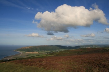
[Main photo: Porlock Bay viewed from the high moor by the A39 with Porlock Beach, Bossington Beach and Bossington Hill]
Beautiful and much visited bay on the north coast of Exmoor National Park
If you’re on holiday in Exmoor National Park, you’ll most likely experience Porlock Bay between Hurlstone Point below Bossington Hill and Gore Point near Porlock Weir. Porlock Beach is at the western end of the bay. Bossington Beach is to the east. Porlock’s famous pebble/shingle ridge lines the bay. Porlock Ridge and Saltmarsh SSSI/Site of Special Scientific Interest extends inland as part of Porlock Vale. It’s a beautiful and much visited area on the north coast of Exmoor National Park.
Location of Porlock Bay
Porlock Bay is located on the north coast of Exmoor National Park.
We’ve positioned Porlock Bay on Google maps. Zoom in on the ‘Satellite’ setting to see its location.
Directions to, and parking at, Porlock Bay
Follow the A39 to Porlock. Various roads take you to the marsh, pebble/shingle ridge and rock and pebble beaches.
You can park at Porlock and walk to the bay.
Alternatively, there are car parks at Bossington on the eastern side and Porlock Weir on the western side of the bay.
You can also walk in on the South West Coast Path that runs across the marsh.
Porlock Bay
Porlock Beach is on the west side of the bay. Bossington Beach is on the east side of the bay. Porlock Ridge and Saltmarsh SSSI/Site of Special Scientific Interest extends inland behind the beaches. Porlock Weir is on the west side of the bay. Bossington village is behind the east side of the bay. We provide more detail on each of these points of interest below:
Porlock Beach
Porlock Beach is marked just east of Porlock Weir on Ordnance Survey mapping. When you are there, you'll find a big rock and pebble beach that sweeps from Gore Point/The Gore past Porlock Weir & Harbour to the eastern side of the coastal village. The beach extends along Porlock Shingle Ridge to the breach in the ridge. Bossington Beach is east of that breach (see below for more information on this). To access Bossington Beach from Porlock Beach, follow the South West Coast Path through Porlock Marsh.
Porlock Weir is a popular and very beautiful place so there are good facilities including The Bottom Ship Inn.
Bossington Beach
Bossington Beach is a rock and pebble beach at the eastern end of Porlock Bay and its famous pebble/shingle ridge. The beach is located at the eastern end of the Exmoor coastline near some of the national park's prettiest villages. It takes its name from nearby Bosssington village. Hurlstone Point overlooks the beach. Bossington Hill rises to the east. Porlock Beach and Porlock Weir are to the west.
There’s a classic view of Porlock Bay and the Exmoor coast from Bossington Hill.
Porlock Beach, Bossington Beach and the Porlock Ridge and Saltmarsh SSSI/Site of Special Scientific Interest
Porlock Beach is part of the Porlock Ridge and Saltmarsh SSSI/Site of Special Scientific Interest which lines Porlock Bay from Hurlstone Point in the east to Gore Point in the west (roughly 4.5km/3m in length) and covers the saltmarsh that sits behind Porlock Shingle Ridge.
The Natural England Porlock Ridge and Saltmarsh SSSI citation provides an excellent description of the area:
'This site comprises a shingle ridge and associated saltmarsh hinterland extending for a distance of approximately 4 kilometres along the west Somerset coast, immediately north of Porlock village. Porlock shingle ridge was formed, as sea level rose during the middle part of the Holocene epoch, from shingle eroded from head deposits which masked the sea cliffs to the west after the last glacial period. This major source of coarse sediment has long since disappeared, leaving only a relatively insignificant input of sediment from occasional cliff falls. The inputs of sediment to the beach ridge from this modern source are too small to sustain the earlier beach profile and the increase in the length of the ridge as it continues to rollback, in a lengthening curve, into Porlock Bay. This means that the ridge has been growing steadily thinner ever since it was formed, a condition exacerbated by the further reduction in shingle inputs caused by the construction of groynes at Gore Point at the western extremity of the ridge. The modern ridge was therefore unable to withstand recent extreme storm events and a breach opened during the storm of October 1996 which flooded the low lying marsh hinterland. Rapid evolution of the beach following the breach is providing a unique opportunity to study the development of a coarse sediment barrier system in an open coast location.' (Source: Natural England Porlock Ridge and Saltmarsh SSSI citation.)
Important note on Porlock Beach and Porlock Shingle Ridge
Please note that the South West Coast Path/public footpath no longer runs across Porlock Shingle Ridge from Bossington Beach to Porlock Beach. According to the Exmoor National Park Authority, it is permanently closed. 'Porlock Shingle Ridge is impassable due to the breach. Do not attempt to cross, even at low water. Follow signs from Bossington to Porlock Weir.' (Source: Exmoor National Park Authority website.)
When walking the area, you're directed through Porlock Marsh behind Porlock Shingle Ridge. The Welsh coastline is across the Bristol Channel. It's well signposted and a beautiful walk. Recommended.
Porlock Weir village
Porlock Weir is an amazing coastal village. In addition to the beach, there’s a beautiful harbour, pub and hotel. The high cliffs west of Porlock Weir are heavily wooded. The South West Coast Path runs through the village and into/from these woods.
Bossington village
Bossington is another beautiful village. It’s located a little further inland than Porlock Weir.
‘Welcome to Bossington, part of the National Trust’s Holnicote Estate. The village is made up of delightful thatched cottages in the local style. If you walk along the riverside path to the sea, you will discover fantastic views, the wildlife of the salt marshes, and several fascinating reminders of the past.
Reminders of the past. If you walk down the beach, you’ll notice some ruined buildings. They include the remains of several lime kilns. Limestone was brought in by boat from South Wales, then burnt in kilns to produce lime. The lime was used as fertiliser on farmland, and for lime mortar and lime-wash for local buildings. There are also the remains of Second World War pillboxes, built to defend the coastline against invasion. Their position shows how sea levels have risen - they were originally set well back from the shoreline.
Journey’s end for Horner Water. Horner Water rushes through the village on its way to meet the sea at Bossington Beach - the end of its eight mile journey from the highest peak of Exmoor. The river emerges into the sea by filtering through the shingle bank. On this last stretch, watch for brown trout which attract the keen interest of herons.
Sea breach creates wildlife haven. In the past, attempts were made to prevent the sea from breaching the shingle ridge across Porlock Bay. The National Trust and other conservation bodies felt that as our climate changes and sea levels rise, natural processes should be allowed to take place. During a storm in 1996, the sea broke through the ridge and flooded the land beyond. Although it seemed disastrous, a large expanse of saltmarsh has now developed and become a precious habitat.
The marsh is now carpeted with plants such as sea purslane, glasswort, sea aster and yellow horned poppies. Its amazing bird life includes huge flocks of finches and buntings, as well as little egret, curlew, lapwing and oystercatcher.’ (Source: National Trust information board at Bossington.)
Historical and cultural attractions near Porlock Bay
Allerford Museum West Somerset Rural Life Museum and Victorian School.
Rowbarrows west of Dunkery Beacon. Explore some of Exmoor’s rich prehistory.
Further away, visit:
Minehead Harbour. Harbour in stunning location at the western end of Minehead Beach under North Hill. ‘There has been a harbour at Minehead since the late 1300s.’ (Source: Minehead Harbour website.)
Dunster Castle (National Trust). Impressive National Trust property dominating the beautiful village of Dunster.
Dunster Yarn Market, Butter Cross and Gallox Bridge (English Heritage). English Heritage properties in Dunster.
Cleeve Abbey (English Heritage). Wonderful English Heritage property just east of Exmoor National Park.
The Ancient Mariner Sculpture in Watchet. The Watchet and Quantock Hills National Landscape area inspired Samuel Taylor Coleridge to write ‘The Rime of the Ancient Mariner’.
Coleridge Cottage (National Trust). Visit the cottage in which Coleridge lived and wrote some of his most famous poetry. William Wordsworth lived, briefly, nearby.
Doone Valley/Doone Country. Richard Doddridge Blackmore's famous novel 'Lorna Doone' is set on Exmoor. Roughly speaking, Doone Valley/Doone Country runs south of Malmsmead and Oare along Badgworhty Water. It’s surrounded by high moor. Great walking.
Gardens near Porlock Bay
Selworthy Green (National Trust). 'There has been a village here since medieval times, but the current cottages were designed by Sir Thomas Dyke Acland in 1828 to create attractive homes for estate pensioners. Beyond the church (14th century), you'll find the village green, surrounded by warm yellow thatched cottages. Notice the tall chimneys which helped to draw the fire and carry sparks away from the thatch.' (Source: information board at Selworthy.)
Further away, visit:
Minehead Blenheim Gardens. Popular gardens behind the Esplanade and North Road at the western end of Minehead Beach.
Dunster Gardens, Dovecote and Tithe Barn. Gardens in the centre of Dunster village.
Dunster Castle (National Trust). The castle is surrounded by many gardens and heavily wooded walkways. The Keep Garden tops the hill on which the castle sits. Lawn’s Bridge, Marshall’s Bridge and Lovers’ Bridge span the River Avill on the eastern side of the castle.
Knightshayes (National Trust). Impressive gardens just off the A396 between Exmoor National Park and Tiverton.
Cothay Manor. Again, gardens outside the national park near Wellington and the M5.
Hestercombe House & Gardens. Gardens located just south of the Quantock Hills National Landscape near Taunton and the M5.
If you don’t mind the drive, RHS Garden Rosemoor by Great Torrington south west of Exmoor National Park is magnificent.
Other attractions near Porlock Bay
West Somerset Railway. Heritage railway running between Minehead and Bishops Lydeard.
Dunster Estate (The Crown Estate). Home to England’s tallest tree. Great for walks and views. Wander up to Conygar Tower.
Dunster Beach. Massive low tide sand and stone beach.
Villages and towns in and near Porlock Bay
Porlock Weir. Amazing coastal village with harbour, pub, hotel and beach.
Bossington. Village by Bossington Beach below Bossington Hill.
Allerford village. Beautiful village further inland known for its packhorse bridge.
Selworthy village. One of the West Country’s prettiest villages, Selworthy is famous for its thatched cottages and village green. Enjoy a cream tea at the Periwinkle Tea Room.
Porlock. Famous West Country village in Porlock Vale.
Horner village. Another beautiful Exmoor village at the bottom of Horner Wood by Horner Water. Enjoy a cream tea at Horner Tea Gardens.
Luccombe. Village not far from the viewpoint and large car park at Webber’s Post with thatched cottages like those at Selworthy.
Minehead. Popular West Country resort town with huge beach and harbour. The start/end of the South West Coast Path.
Dunster. Essential visiting. Beautiful village dominated by Dunster Castle (National Trust) with English Heritage properties, Dunster National Park Visitor Centre and plenty of shops and places to eat and drink. Park of Dunster Estate (Crown Estate) with England’s tallest tree and super walk and views.
Photo Gallery

